Tuesday, January 24, 2012

Boats moored at a harbor, Lake Garda, Gardone Riviera, Italy

Via Flickr:
Visit Our Website! II Facebook II Twitter II Tumblr II Capture Arkansas


For image licensing requests or photo related questions click here! or message me through Flickrmail!


Lake Garda (Italian: Lago di Garda or Benaco) is the largest lake in Italy. It is located in Northern Italy, about half-way between Brescia and Verona, and between Venice and Milan. Glaciers formed this alpine region at the end of the last Ice Age. The lake and its shoreline are divided between the provinces of Verona (to the southeast), Brescia (southwest), and Trentino (north). Being easily accessible from the north via the Brenner Pass, the lake is a major tourist destination, including a number of exclusive hotels and resorts along its shore.

Geography

The northern part of the lake is narrower, surrounded by mountains, the majority of which belong to the Gruppo del Baldo. The shape is typical of a moraine valley, probably having been formed under the action of a Paleolithic glacier. Although traces of the glacier's actions are evident today, in more recent years it has been hypothesized that the glacier occupied a previously existing depression, created by stream erosion 5 to 6 million years ago.
The lake has numerous small islands and five main ones, the largest being Isola del Garda. Nearby to the south is Isola San Biagio, also known as the Isola dei Conigli ("Island of the Rabbits"). Both are offshore of San Felice del Benaco, on the west side. The three other main islands are Isola dell'Olivo, Isola di Sogno, and Isola di Trimelone, all further north near the east side. The main tributary is the Sarca River, while the only emissary is the Mincio River.
Wednesday, January 18, 2012

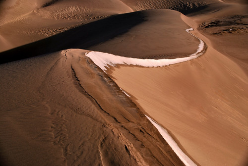
DESERT SPINE

DESERT SPINE by Jeka World Photography
DESERT SPINE, a photo by Jeka World Photography on Flickr.

Via Flickr:
Visit Our Website! II Facebook II Twitter II Tumblr


For image licensing requests or photo related questions click here! or message me through Flickrmail!

GREAT SAND DUNES NATIONAL PARK AND PRESERVE:

Great Sand Dunes National Monument was one of the many United States national parks and monuments created during the Great Depression (1932). In its original form it covered only the dunes themselves. However, it has expanded significantly since its roots, due in large part to concern among residents of nearby communities about the need to protect the watershed containing the dunes. Recent actions in 2000 and 2004 led first to the creation of a "preserve" adjoining the monument, and then to the designation of the combined monument/preserve as a full-fledged national park.
[edit]Landscape
The park includes North America's tallest dunes, which rise over 750 feet high against the rugged Sangre de Cristo Mountains. The wind-shaped dunes glow beneath the rugged backdrop of the mountains. This geologic wonderland contains over 30 square miles of massive dunes, and also includes alpine lakes and tundra, six peaks over 13,000' in elevation, ancient spruce and pine forests, large stands of aspen and cottonwood, grasslands, and wetlands--all habitat for diverse wildlife and plant species.

Saturday, January 14, 2012

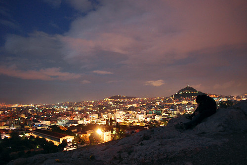
Athens from Mars Hill (Areopagus)

Via Flickr:
Visit Our Website! II Facebook II Twitter II Tumblr


For image licensing requests or photo related questions click here! or message me through Flickrmail!


Myth and Mystery about Areopagus

According to Greek mythology, Ares (the god of war, known to the Romans as Mars) was tried here by the gods for the murder of Poseidon's son Alirrothios. It is this legend that gives the hill its various names. Another legend says that the hill was the site of the trial of Orestes for killing his stepmother and her lover, Clytemnestra and Aegisthus.

History about Areopagus

In pre-classical times (before the 5th century BC), the Areopagus was the council of elders of the city, like the Roman Senate. Like the Senate, its membership derived from those who had held high public office, in this case that of Archon. In 462 BC, Ephialtes put through reforms which deprived the Areopagus of almost all its functions except that of a murder tribunal.

In classical times, the Areopagus functioned as the chief homicide court of Athens. At the foot of the Areopagus was a temple dedicated to the Erinyes, where murderers could find sanctuary.

Areopagus in the Bible

The Areopagus, like most city-state institutions, continued to function in Roman times, and it was then that the Apostle Paul delivered his famous speech about the identity of "the Unknown God." According to the biblical account (Acts 17):

A group of Epicurean and Stoic philosophers began to dispute with him. Some of them asked, "What is this babbler trying to say?" Others remarked, "He seems to be advocating foreign gods." They said this because Paul was preaching the good news about Jesus and the resurrection.

Then they took him and brought him to a meeting of the Areopagus, where they said to him, "May we know what this new teaching is that you are presenting? You are bringing some strange ideas to our ears, and we want to know what they mean. (All the Athenians and the foreigners who lived there spent their time doing nothing but talking about and listening to the latest ideas.)

Paul then stood up in the meeting of the Areopagus and said: "Men of Athens! I see that in every way you are very religious. For as I walked around and looked carefully at your objects of worship, I even found an altar with this inscription: TO AN UNKNOWN GOD. Now what you worship as something unknown I am going to proclaim to you."

...When they heard about the resurrection of the dead, some of them sneered, but others said, "We want to hear you again on this subject." At that, Paul left the Council. A few men became followers of Paul and believed. Among them was Dionysius, a member of the Areopagus, also a woman named Damaris, and a number of others.

Friday, January 13, 2012

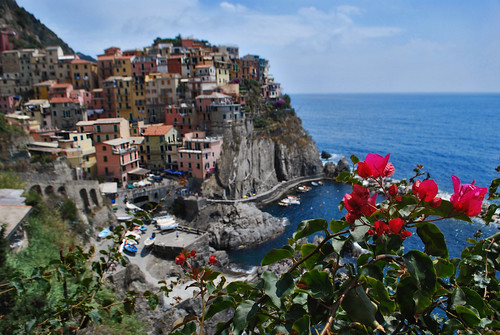
Manarola in Cinque Terre

Via Flickr:
Visit Our Website! II Facebook II Twitter II Tumblr


For image licensing requests or photo related questions click here! or message me through Flickrmail!

Manarola may be the oldest of the towns in the Cinque Terre, with the cornerstone of the church, San Lorenzo, dating from 1338. The local dialect is Manarolese, which is marginally different from the dialects in the nearby area. The name "Manarola" is probably dialectical evolution of the Latin, "magna rota". In the Manarolese dialect this was changed to "magna roea" which means "large wheel", in reference to the mill wheel in the town [1].
Manarola's primary industries have traditionally been fishing and wine-making. The local wine, called Sciacchetrà, is especially renowned; references from Roman writings mention the high quality of the wine produced in the region. In recent years, Manarola and its neighboring towns have become popular tourist destinations, particularly in the summer months. Tourist attractions in the region include a famous walking trail between Manarola and Riomaggiore (called Via dell'Amore, "Love's Trail") and hiking trails in the hills and vineyards above the town. Manarola is one of the five villages. Mostly all of the houses are bright and colourful.

Thursday, January 12, 2012

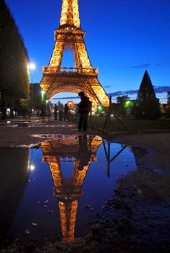
Reflections of Paris

Via Flickr:
Visit Our Website! II Facebook II Twitter II Tumblr


For image licensing requests or photo related questions click here! or message me through Flickrmail!

After a rainy afternoon in Paris. The clouds finally broke away and left us with these beautiful puddles reflecting the Eiffel Towers iconic glow.

The Eiffel Tower (French: La Tour Eiffel, [tuʁ ɛfɛl], nickname La dame de fer, the iron lady) is a wrought iron lattice tower located on the Champ de Mars in Paris. Built in 1889, it has become both a global icon of France and one of the most recognizable structures in the world. The tower is the tallest building in Paris[10] and the most-visited paid monument in the world; millions of people ascend it every year. Named after its designer, engineer Gustave Eiffel, the tower was built as the entrance arch to the 1889 World's Fair.
The tower stands 324 metres (1,063 ft) tall, about the same height as an 81-storey building. During its construction, the Eiffel Tower surpassed the Washington Monument to assume the title of the tallest man-made structure in the world, a title it held for 41 years, until the Chrysler Building in New York City was built in 1930. However, due to the addition, in 1957, of the antenna atop the Eiffel Tower, it is now taller than the Chrysler Building. Not including broadcast antennas, it is the second-tallest structure in France, after the Millau Viaduct.
The tower has three levels for visitors. Tickets can be purchased to ascend, by stairs or lift, to the first and second levels. The walk from ground level to the first level is over 300 steps, as is the walk from the first to the second level. The third and highest level is accessible only by elevator. Both the first and second levels feature restaurants.
The tower has become the most prominent symbol of both Paris and France, often in the establishing shot of films set in the city.

Wednesday, January 11, 2012

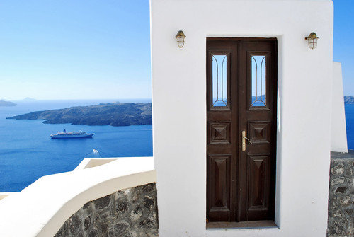
Door to Paradise

Via Flickr:
Visit Our Website! II Facebook II Twitter II Tumblr

For image licensing requests or photo related questions click here! or message me through Flickrmail.


Santorini (Greek: Σαντορίνη, pronounced [sadoˈrini]), officially Thira (Greek: Θήρα [ˈθira]), is an island located in the southern Aegean Sea, about 200 km (120 mi) southeast from Greece's mainland. It is the largest island of a small, circular archipelago which bears the same name and is the remnant of a volcanic caldera. It forms the southernmost member of the Cyclades group of islands, with an area of approximately 73 km2 (28 sq mi) and a 2001 census population of 13,670. The municipality of Santorini comprises the inhabited islands of Santorini and Therasia and the uninhabited islands of Nea Kameni, Palaia Kameni, Aspronisi, and Christiana. The total land area is 90.623 km2 (34.990 sq mi). Santorini is part of the Thira regional unit.
www.jekaworldphotography.com/

Tuesday, January 10, 2012

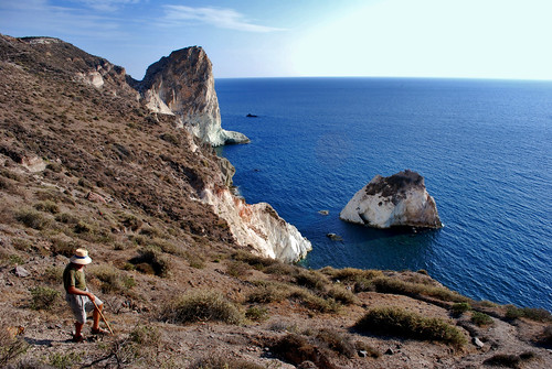
White Beach on The Island of Santorini

Via Flickr:
Visit Our Website! II Facebook II Twitter II Tumblr

For image licensing requests or photo related questions click here! or message me through Flickrmail.

Close to Kokkini Ammos, Aspri Ammos is known as the 'White Beach' due to its backdrop of white cliff faces. Aspri Ammos enjoys a very secluded and isolated spot on Santorini and can be reached by either sea (from Red Beach) or on foot

www.jekaworldphotography.com/