Via Flickr:
Visit Our Website! II Facebook II Twitter II Tumblr II Capture Arkansas
For image licensing requests or photo related questions click here! or message me through Flickrmail!
North Point State Park is a Chesapeake Bay waterfront park located in Edgemere, MD. The park is situated on the grounds that once were the home of Bay Shore Amusement Park, which was one of the premiere amusement parks in Maryland from 1906 - 1947. Current visitors to the park can enjoy hiking, wading, birdwatching, bicycling, fishing, picnicking, group events, and remnants of Bay Shore Park, such as the restored Trolley Station and fountain.
Wednesday, February 29, 2012
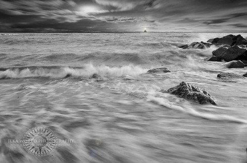
Endless Horizon
Saturday, February 25, 2012
Mossy cascade in mountain stream. Great Smoky Mountains National Park, Tennessee, Appalachian, USA
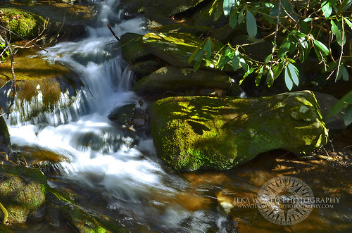
Mossy cascade in mountain stream. Great Smoky Mountains National Park, Tennessee, Appalachian, USA, a photo by Jeka World Photography (Catching up!!) on Flickr.
Via Flickr:
Visit Our Website! II Facebook II Twitter II Tumblr II Capture Arkansas
For image licensing requests or photo related questions click here! or message me through Flickrmail!
Great Smoky Mountains National Park is a United States National Park and UNESCO World Heritage Site that straddles the ridgeline of the Great Smoky Mountains, part of the Blue Ridge Mountains, which are a division of the larger Appalachian Mountain chain. The border between Tennessee and North Carolina runs northeast to southwest through the centerline of the park. It is the most visited national park in the United States. On its route from Maine to Georgia, the Appalachian Trail also passes through the center of the park. The park was chartered by the United States Congress in 1934 and officially dedicated by President Franklin Delano Roosevelt in 1940. It encompasses 814 square miles (2,110 km2), making it one of the largest protected areas in the eastern United States. The main park entrances are located along U.S. Highway 441 (Newfound Gap Road) at the towns of Gatlinburg, Tennessee, and Cherokee, North Carolina. It was the first national park whose land and other costs were paid for in part with federal funds; previous parks were funded wholly with state money or private funds.
Elevations in the park range from 876 feet (267 m) at the mouth of Abrams Creek to 6,643 feet (2,025 m) at the summit of Clingmans Dome. Within the park a total of sixteen mountains reach higher than 6,000 feet (1829 m).
The wide range of elevations mimics the latitudinal changes found throughout the entire eastern United States. Indeed, ascending the mountains is comparable to a trip from Tennessee to Canada. Plants and animals common in the country's Northeast have found suitable ecological niches in the park's higher elevations, while southern species find homes in the balmier lower reaches.
The observation tower at Clingmans Dome, the highest point in the national park.
During the most recent ice age, the northeast-to-southwest orientation of the Appalachian mountains allowed species to migrate southward along the slopes rather than finding the mountains to be a barrier. As climate warms, many northern species are now retreating upward along the slopes and withdrawing northward,[8] while southern species are expanding.[9]
The park normally has very high humidity and precipitation, averaging from 55 inches (1,400 mm) per year in the valleys to 85 inches (2,200 mm) per year on the peaks. This is more annual rainfall than anywhere in the United States outside the Pacific Northwest and parts of Alaska. It is also generally cooler than the lower elevations below, and most of the park has a humid continental climate more comparable to locations much farther north, as opposed to the humid subtropical climate in the lowlands. The park is almost 95 percent forested, and almost 36 percent of it, 187,000 acres (760 km2), is estimated by the Park Service to be old growth forest with many trees that predate European settlement of the area. It is one of the largest blocks of deciduous, temperate, old growth forest in North America.
The variety of elevations, the abundant rainfall, and the presence of old growth forests give the park an unusual richness of biota. About 10,000 species of plants and animals are known to live in the park, and estimates as high as an additional 90,000 undocumented species may also be present.
Park officials count more than 200 species of birds, 66 species of mammals, 50 species of fish, 39 species of reptiles, and 43 species of amphibians, including many lungless salamanders. The park has a noteworthy black bear population, numbering at least 1,800. An experimental re-introduction of elk (wapiti) into the park began in 2001.
Over 100 species of trees grow in the park. The lower region forests are dominated by deciduous leafy trees. At higher altitudes, deciduous forests give way to coniferous trees like Fraser Fir. In addition, the park has over 1,400 flowering plant species and over 4,000 species of non-flowering plants.
Friday, February 24, 2012
The Beacon
Via Flickr:
Visit Our Website! II Facebook II Twitter II Tumblr II Capture Arkansas
For image licensing requests or photo related questions click here! or message me through Flickrmail!
Sandy Point State Park is a Maryland state park located at Sandy Point, at the western end of the Chesapeake Bay Bridge in Anne Arundel County, Maryland.[1] The park is at the site of a former ferry landing that served the Chesapeake Bay Ferry System. Located at the park is the historic home Sandy Point Farmhouse, listed on the National Register of Historic Places in 1972.
Thursday, February 23, 2012
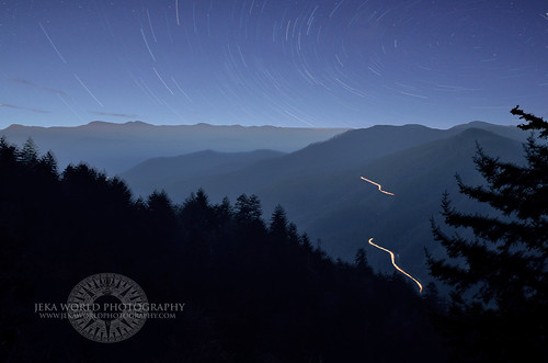
Smoky Mountain Trails
Via Flickr:
Visit Our Website! II Facebook II Twitter II Tumblr II Capture Arkansas
For image licensing requests or photo related questions click here! or message me through Flickrmail!
We had to brave a cold morning on top of the smokies for quite a while for this image. Taking numerous long shutter captures throughout the morning and layering them later. In the end I believe that it was all definitely worth it!
Great Smoky Mountains National Park is a United States National Park and UNESCO World Heritage Site that straddles the ridgeline of the Great Smoky Mountains, part of the Blue Ridge Mountains, which are a division of the larger Appalachian Mountain chain. The border between Tennessee and North Carolina runs northeast to southwest through the centerline of the park. It is the most visited national park in the United States. On its route from Maine to Georgia, the Appalachian Trail also passes through the center of the park. The park was chartered by the United States Congress in 1934 and officially dedicated by President Franklin Delano Roosevelt in 1940. It encompasses 814 square miles (2,110 km2), making it one of the largest protected areas in the eastern United States. The main park entrances are located along U.S. Highway 441 (Newfound Gap Road) at the towns of Gatlinburg, Tennessee, and Cherokee, North Carolina. It was the first national park whose land and other costs were paid for in part with federal funds; previous parks were funded wholly with state money or private funds.
Wednesday, February 22, 2012
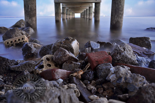
All That Remains

Via Flickr:
Visit Our Website! II Facebook II Twitter II Tumblr II Capture Arkansas
For image licensing requests or photo related questions click here! or message me through Flickrmail!
About North Point Park:
North Point State Park is located in Baltimore County on the shores of the Chesapeake Bay and is surrounded by beautiful and fascinating natural and historical resources. It consists of 1,310 acres off Old North Point Road in Edgemere.
About The Chesapeake Bay:
The Chesapeake Bay is the largest estuary in the United States. It lies off the Atlantic Ocean, surrounded by Maryland and Virginia. The Chesapeake Bay's drainage basin covers 64,299 square miles (166,534 km2) in the District of Columbia and parts of six states: New York, Pennsylvania, Delaware, Maryland, Virginia, and West Virginia. More than 150 rivers and streams drain into the bay.
The Chesapeake Bay is approximately 200 miles (300 km) long, from the Susquehanna River in the north to the Atlantic Ocean in the south. At its narrowest point between Kent County's Plum Point (near Newtown) and the Harford County shore near Romney Creek, the bay is 2.8 miles (4.5 km) wide; at its widest point, just south of the mouth of the Potomac River, it is 30 miles (50 km) wide. Total shoreline for the bay and its tributaries is 11,684 miles (18,804 km), and the surface area of the bay and its major tributaries is 4,479 square miles (11,601 km2). Average depth of the bay is 46 feet (14 m) and the maximum depth is 208 feet (63 m).
The bay is spanned in two places. The Chesapeake Bay Bridge crosses the bay in Maryland from Sandy Point (near Annapolis) to Kent Island; and the Chesapeake Bay Bridge-Tunnel in Virginia connects Virginia Beach to Cape Charles. The bay has environmental issues but is noted for its beauty; in recent years, a pattern has been that it is becoming "emptier", with fewer crabs, oysters, and watermen.
Thursday, February 9, 2012
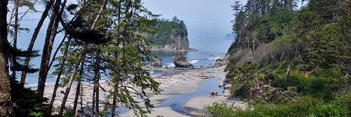
Ruby Beach
Via Flickr:
Visit Our Website! II Facebook II Twitter II Tumblr II Capture Arkansas
Ruby Beach is the northernmost of the southern beaches in the coastal section of Olympic National Park. It is located on Highway 101, in Jefferson County, 27 miles south of the town of Forks, Washington. Per National Park Service,Ruby Beach is "Not in Park but right on edge."
Like virtually all beaches on the northern coast, Ruby Beach has a tremendous amount of driftwood. It is notable for the number of sea stacks there.
Wednesday, February 8, 2012
Dreaming of the Sea

Via Flickr:
Visit Our Website! II Facebook II Twitter II Tumblr II Capture Arkansas
Santorini is a small, circular archipelago of volcanic islands located in the southern Aegean Sea. It lies 200 km southeast from Greece's mainland. It is also known as Thera or Thira, forming the southernmost member of the Cyclades group of islands.
Santorini is essentially what remains of an enormous volcanic explosion, destroying the earliest settlements on what was formerly a single island, and leading to the creation of the current geological caldera.The volcano is still active, and the last eruption was in 1950, causing an earthquake that destroyed many villages on the island.
Its spectacular physical beauty, along with a dynamic nightlife, have made the island one of Europe's tourist hotspots.
Wednesday, February 1, 2012
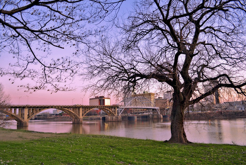
A Tree Stands Beside the River
Via Flickr:
Visit Our Website! II Facebook II Twitter II Tumblr II Capture Arkansas
For image licensing requests or photo related questions click here! or message me through Flickrmail!
A tree stands proudly beside the Arkansas River and watches an ever changing Little Rock grow before it.
Little Rock is the capital and the largest city of the U.S. state of Arkansas. The Metropolitan Statistical Area (MSA) had a population of 699,757 people in the 2010 census. The MSA is in turn included in the Little Rock–North Little Rock–Pine Bluff, Arkansas Combined Statistical Area, which had a population of 877,091 in the 2010 census, making it the 47th largest combined statistical area in America. As of the 2010 US Census, Little Rock had a population of 193,524, making it the 118th largest city in America. It is the county seat of Pulaski County.
Located near the geographic center of Arkansas, Little Rock derives its name from a small rock formation on the south bank of the Arkansas River called la Petite Roche (French: "the little rock"). The "little rock" was used by early river traffic as a landmark and became a well-known river crossing. The "little rock" is across the river from "big rock", a large bluff at the edge of the river, which was once used as a rock quarry.
Subscribe to:
Posts (Atom)