Thursday, April 19, 2012

MARVEL (The stark realization that we are just a speck on this earth and time)

Via Flickr:
Visit Our Website! II Facebook II Twitter II Tumblr II Capture Arkansas

For image licensing requests or photo related questions click here! or message me through Flickrmail!

___________________________________________
The Story:
---------------------------------------------------------------------------
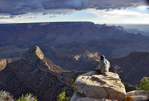
Some travel sights in this world evoke so much emotion, and truly inspire awe. The Grand Canyon is probably the world’s most impressive natural wonder, and one can never seem to adequately express the grandeur of this sight. Setting up the tripod and sitting out on this rock outcrop I hoped to actually convey a little of this feeling to the viewer.
___________________________________________
About The Grand Canyon:
---------------------------------------------------------------------------

The Grand Canyon is a steep-sided canyon carved by the Colorado River in the United States in the state of Arizona. It is largely contained within the Grand Canyon National Park, one of the first national parks in the United States. President Theodore Roosevelt was a major proponent of preservation of the Grand Canyon area, and visited it on numerous occasions to hunt and enjoy the scenery.
The Grand Canyon is 277 miles (446 km) long, up to 18 miles (29 km) wide and attains a depth of over a mile (6,000 feet / 1,800 metres) Nearly two billion years of the Earth's geological history have been exposed as the Colorado River and its tributaries cut their channels through layer after layer of rock while the Colorado Plateau was uplifted. While the specific geologic processes and timing that formed the Grand Canyon are the subject of debate by geologists, recent evidence suggests the Colorado River established its course through the canyon at least 17 million years ago. Since that time, the Colorado River continued to erode and form the canyon to its present-day configuration.
Before European immigration, the area was inhabited by Native Americans who built settlements within the canyon and its many caves. The Pueblo people considered the Grand Canyon ("Ongtupqa" in Hopi language) a holy site and made pilgrimages to it. The first European known to have viewed the Grand Canyon was García López de Cárdenas from Spain, who arrived in 1540.

Saturday, April 14, 2012

EDEN

Via Flickr:
Visit Our Website! II Facebook II Twitter II Tumblr ll 500px II Capture Arkansas


For image licensing requests or photo related questions click here! or message me through Flickrmail!

This is part of the white river formed by glacier melt that runs through the Partnachklamm.

About PARTNACHKLAMM:
One of Germany’s natural wonders lies just around the corner from the twin towns of Garmisch-Partenkirchen in the Bavarian Alps.

The Partnachklamm is a spectacular 700m gorge that frames a surging white-water river.
You can walk the length of the gorge along a pathway cut into the limestone rock just a few metres above the river.

Tuesday, April 10, 2012

Summer Nights on Lake Garda

Via Flickr:
Visit Our Website! II Facebook II Twitter II Tumblr II Capture Arkansas

For image licensing requests or photo related questions click here! or message me through Flickrmail!

About Gargnano:
This small port town was an important Franciscan center in the 13th century, and now comes alive in the summer months when German tourists, many of whom have villas here, crowd the small pebble beaches. An Austrian flotilla bombarded the town in 1866, and some of the houses still bear marks of cannon fire. Mussolini owned two houses in Gargnano: one is now a language school and the other, Villa Feltrinelli, has been restored and reopened as a luxury hotel.

About Lake Garda:

Lake Garda (Italian: Lago di Garda or Benaco) is the largest lake in Italy. It is located in Northern Italy, about half-way between Brescia and Verona, and between Venice and Milan. Glaciers formed this alpine region at the end of the last ice age. The lake and its shoreline are divided between the provinces of Verona (to the southeast), Brescia (southwest), and Trentino (north). Being easily accessible from the north via the Brenner Pass, the lake is a major tourist destination, including a number of exclusive hotels and resorts along its shore.

The northern part of the lake is narrower, surrounded by mountains, the majority of which belong to the Gruppo del Baldo. The shape is typical of a moraine valley, probably having been formed under the action of a Paleolithic glacier. Although traces of the glacier's actions are evident today, in more recent years it has been hypothesized that the glacier occupied a previously existing depression, created by stream erosion 5 to 6 million years ago.
The lake has numerous small islands and five main ones, the largest being Isola del Garda. Nearby to the south is Isola San Biagio, also known as the Isola dei Conigli ("Island of the Rabbits"). Both are offshore of San Felice del Benaco, on the west side. The three other main islands are Isola dell'Olivo, Isola di Sogno, and Isola di Trimelone, all further north near the east side. The main tributary is the Sarca River, while the only emissary is the Mincio River.
[edit]Localities and sights
The ancient fortified town of Sirmione, located on the south of the lake, is one particularly popular destination, home to the Virgilio & Catullo Spa Complexes, as well as numerous restaurants, bars, hotels, fashion stores and a market. The picturesque Scaliger castle dates from the 13th century. The Roman poet Catullus had a villa here, and visitors can see a ruined Roman spa named the Grotte di Catullo (Grotto of Catullus) although there is no evidence linking him to this particular building. The sulfur springs at the tip of the peninsula have a reputation for the healing of catarrhal conditions, particularly those involving the ear. Nearby, there is Gardaland, one of the most famous theme parks in Italy.

Friday, April 6, 2012

The Magic of Bruges

Via Flickr:
Visit Our Website! II Facebook II Twitter II Tumblr II Capture Arkansas

For image licensing requests or photo related questions click here! or message me through Flickrmail!


One evening while wondering the cobblestone alleys of Bruges the soaring 119m (396-ft.) spire of the Church of Our Lady (Onze-Lieve-Vrouwekerk) standing high above the streets and canals, seemed to almost glow red as the last rays of the days sunlight clung to it. Bruges is truly a magical place despite how colin farrells character on in Bruges felt about it. “If I'd grown up on a farm and was retarded, Bruges might impress me. But I didn't, so it doesn't.” A medieval city that makes you go back centuries the first second you enter it, through its old houses, canals with beautiful swans and warm, picturesque market squares. The bourgeois feeling is mesmerizing you wherever you go, on the cobbled streets with charming historical houses or along the canals that you can find almost anywhere. The historic city centre was added to the Unesco’s World Heritage List and the current city boundaries still coincide exactly with those of the medieval city centre.

About The Church of Our Lady:

(Dutch: Onze-Lieve-Vrouwekerk) in Bruges, Belgium, dates mainly from the 13th, 14th and 15th centuries.
Its tower, at 119 meters in height, remains the tallest structure in the city and the second tallest brickwork tower in the world (the tallest being the St. Martin's Church in Landshut, Germany).
In the choir space behind the high altar are the tombs of Charles the Bold, last Valois Duke of Burgundy, and his daughter, the duchess Mary. The gilded bronze effigies of both father and daughter repose at full length on polished slabs of black stone. Both are crowned, and Charles is represented in full armor and wearing the decoration of the Order of the Golden Fleece.
The altarpiece of the large chapel in the southern aisle enshrines the most celebrated art treasure of the church—a white marble sculpture of the Madonna and Child created by Michelangelo around 1504. Probably meant originally for Siena Cathedral, it was purchased in Italy by two Brugean merchants, the brothers Jan and Alexander Mouscron, and in 1514 donated to its present home. The sculpture was twice recovered after being looted by foreign occupiers—French revolutionaries circa 1794 and Nazi Germans in 1944.

About Bruges:
/ˈbruːʒ/ in English; Dutch: Brugge, [ˈbrʏʝə], French: Bruges, [ˈbʁyːʒ], German: Brügge, [ˈbrʏɡə]) is the capital and largest city of the province of West Flanders in the Flemish Region of Belgium. It is located in the northwest of the country.
The historic city centre is a prominent World Heritage Site of UNESCO. It is oval-shaped and about 430 hectares in size. The area of the whole city amounts to more than 13,840 hectares, including 1,075 hectares off the coast, at Zeebrugge (meaning "Brugge aan Zee" or "Bruges on Sea"). The city's total population is 117,073 (1 January 2008), of which around 20,000 live in the historic centre. The metropolitan area, including the outer commuter zone, covers an area of 616 km² and has a total of 255,844 inhabitants as of 1 January 2008.
Along with a few other canal-based northern cities, such as Amsterdam, it is sometimes referred to as "The Venice of the North".
Bruges has a significant economic importance thanks to its port. At one time, it was the "chief commercial city" of the world.

Thursday, April 5, 2012

The Magic of Bruges

Via Flickr:
Visit Our Website! II Facebook II Twitter II Tumblr II Capture Arkansas

For image licensing requests or photo related questions click here! or message me through Flickrmail!


One evening while wondering the cobblestone alleys of Bruges the soaring 119m (396-ft.) spire of the Church of Our Lady (Onze-Lieve-Vrouwekerk) standing high above the streets and canals, seemed to almost glow red as the last rays of the days sunlight clung to it. Bruges is truly a magical place despite how colin farrells character on in Bruges felt about it. “If I'd grown up on a farm and was retarded, Bruges might impress me. But I didn't, so it doesn't.” A medieval city that makes you go back centuries the first second you enter it, through its old houses, canals with beautiful swans and warm, picturesque market squares. The bourgeois feeling is mesmerizing you wherever you go, on the cobbled streets with charming historical houses or along the canals that you can find almost anywhere. The historic city centre was added to the Unesco’s World Heritage List and the current city boundaries still coincide exactly with those of the medieval city centre.

About The Church of Our Lady:

(Dutch: Onze-Lieve-Vrouwekerk) in Bruges, Belgium, dates mainly from the 13th, 14th and 15th centuries.
Its tower, at 119 meters in height, remains the tallest structure in the city and the second tallest brickwork tower in the world (the tallest being the St. Martin's Church in Landshut, Germany).
In the choir space behind the high altar are the tombs of Charles the Bold, last Valois Duke of Burgundy, and his daughter, the duchess Mary. The gilded bronze effigies of both father and daughter repose at full length on polished slabs of black stone. Both are crowned, and Charles is represented in full armor and wearing the decoration of the Order of the Golden Fleece.
The altarpiece of the large chapel in the southern aisle enshrines the most celebrated art treasure of the church—a white marble sculpture of the Madonna and Child created by Michelangelo around 1504. Probably meant originally for Siena Cathedral, it was purchased in Italy by two Brugean merchants, the brothers Jan and Alexander Mouscron, and in 1514 donated to its present home. The sculpture was twice recovered after being looted by foreign occupiers—French revolutionaries circa 1794 and Nazi Germans in 1944.

About Bruges:
/ˈbruːʒ/ in English; Dutch: Brugge, [ˈbrʏʝə], French: Bruges, [ˈbʁyːʒ], German: Brügge, [ˈbrʏɡə]) is the capital and largest city of the province of West Flanders in the Flemish Region of Belgium. It is located in the northwest of the country.
The historic city centre is a prominent World Heritage Site of UNESCO. It is oval-shaped and about 430 hectares in size. The area of the whole city amounts to more than 13,840 hectares, including 1,075 hectares off the coast, at Zeebrugge (meaning "Brugge aan Zee" or "Bruges on Sea"). The city's total population is 117,073 (1 January 2008), of which around 20,000 live in the historic centre. The metropolitan area, including the outer commuter zone, covers an area of 616 km² and has a total of 255,844 inhabitants as of 1 January 2008.
Along with a few other canal-based northern cities, such as Amsterdam, it is sometimes referred to as "The Venice of the North".
Bruges has a significant economic importance thanks to its port. At one time, it was the "chief commercial city" of the world.

Wednesday, April 4, 2012

Rocky Sunset

Via Flickr:
Visit Our Website! II Facebook II Twitter II Tumblr II Capture Arkansas

For image licensing requests or photo related questions click here! or message me through Flickrmail!

North Point State Park is a Chesapeake Bay waterfront park located in Edgemere, MD. The park is situated on the grounds that once were the home of Bay Shore Amusement Park, which was one of the premiere amusement parks in Maryland from 1906 - 1947. Current visitors to the park can enjoy hiking, wading, birdwatching, bicycling, fishing, picnicking, group events, and remnants of Bay Shore Park, such as the restored Trolley Station and fountain.