
Via Flickr:
Visit Our Website! II Facebook II Twitter II Tumblr
Due to the volcanic fertile soil, Santorini is famous for its unique products such as the white aubergine, the little cherry tomatoes, fava etc. You must taste tomato-balls (tomatokeftedes) made from the cherry tomatoes and mousaka with local aubergines and vegetables.greek salad Santorini has been famous for its wines from the ancient years. The fertile earth helps the cultivation and the development of vineyards. Many famous wineries can be found in Santorini such as Boutari, Cavana Roussos and Santo wines. Taste all 3 kinds - Brusko (Red / dry / strong), Nichteri (White / dry / strong), Vissando (Red / sweet / extremely strong; reminds the liqueur). As far as sweets are concerned, taste spoon-sweets which are made from whole cherry tomatoes seasoned with cinnamon and whole almonds.
About Santorini:
Santorini (Greek: Σαντορίνη, pronounced [sadoˈrini]), officially Thira (Greek: Θήρα [ˈθira]), is an island located in the southern Aegean Sea, about 200 km (120 mi) southeast from Greece's mainland. It is the largest island of a small, circular archipelago which bears the same name and is the remnant of a volcanic caldera. It forms the southernmost member of the Cyclades group of islands, with an area of approximately 73 km2 (28 sq mi) and a 2001 census population of 13,670. The municipality of Santorini comprises the inhabited islands of Santorini and Therasia and the uninhabited islands of Nea Kameni, Palaia Kameni, Aspronisi, and Christiana. The total land area is 90.623 km2 (34.990 sq mi). Santorini is part of the Thira regional unit.
Santorini is essentially what remains after an enormous volcanic explosion that destroyed the earliest settlements, on a formerly single island, and created the current geological caldera. A giant central, rectangular lagoon, which measures about 12 by 7 km (7.5 by 4.3 mi), is surrounded by 300 m (980 ft) high, steep cliffs on three sides. The main island slopes downward to the Aegean Sea. On the fourth side, the lagoon is separated from the sea by another much smaller island called Therasia; the lagoon is connected to the sea in two places, in the northwest and southwest. The water in the center of the lagoon is nearly 400 m (1,300 ft) deep, thus making it a safe harbor for all kinds of shipping. The island's harbors all lie in the lagoon, and there are no ports on the perimeter of the island; the capital, Fira, clings to the top of the cliff looking down on the lagoon. The volcanic rocks present from the prior eruptions feature olivine and have a notably small presence of hornblende.
It is the most active volcanic center in the South Aegean Volcanic Arc, though what remains today is chiefly a water-filled caldera. The volcanic arc is approximately 500 km (310 mi) long and 20 to 40 km (12 to 25 mi) wide. The region first became volcanically active around 3–4 million years ago, though volcanism on Thera began around 2 million years ago with the extrusion of dacitic lavas from vents around the Akrotiri.
The island is the site of one of the largest volcanic eruptions in recorded history: the Minoan eruption (sometimes called the Thera eruption), which occurred some 3600 years ago at the height of the Minoan civilization. The eruption left a large caldera surrounded by volcanic ash deposits hundreds of feet deep and may have led indirectly to the collapse of the Minoan civilization on the island of Crete, 110 km (68 mi) to the south, through a gigantic tsunami. This theory is not, however, supported by chronology, in that the collapse of the Minoan civilization did not occur at the date of the tsunami, but some 90 years later.[citation needed] Another popular theory holds that the Thera eruption is the source of the legend of Atlantis.
www.jekaworldphotography.com/
Saturday, December 24, 2011
Dinning on the Caldera
Wednesday, December 21, 2011
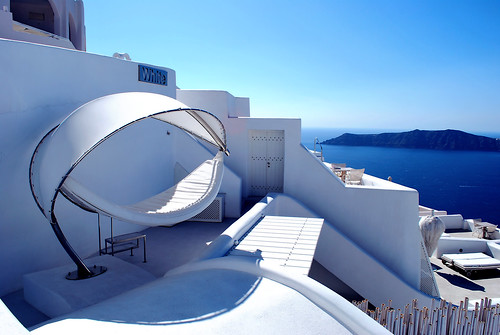
White Hotel Santorini
Via Flickr:
Visit Our Website! II Facebook II Twitter II Tumblr
Built on the highest point of the caldera, in Imerovigli village, White Hotel offers its guests exceptional service in an idyllic environment complimented by breathtaking views.
About Santorini:
Santorini (Greek: Σαντορίνη, pronounced [sadoˈrini]), officially Thira (Greek: Θήρα [ˈθira]), is an island located in the southern Aegean Sea, about 200 km (120 mi) southeast from Greece's mainland. It is the largest island of a small, circular archipelago which bears the same name and is the remnant of a volcanic caldera. It forms the southernmost member of the Cyclades group of islands, with an area of approximately 73 km2 (28 sq mi) and a 2001 census population of 13,670. The municipality of Santorini comprises the inhabited islands of Santorini and Therasia and the uninhabited islands of Nea Kameni, Palaia Kameni, Aspronisi, and Christiana. The total land area is 90.623 km2 (34.990 sq mi). Santorini is part of the Thira regional unit.
Santorini is essentially what remains after an enormous volcanic explosion that destroyed the earliest settlements, on a formerly single island, and created the current geological caldera. A giant central, rectangular lagoon, which measures about 12 by 7 km (7.5 by 4.3 mi), is surrounded by 300 m (980 ft) high, steep cliffs on three sides. The main island slopes downward to the Aegean Sea. On the fourth side, the lagoon is separated from the sea by another much smaller island called Therasia; the lagoon is connected to the sea in two places, in the northwest and southwest. The water in the center of the lagoon is nearly 400 m (1,300 ft) deep, thus making it a safe harbor for all kinds of shipping. The island's harbors all lie in the lagoon, and there are no ports on the perimeter of the island; the capital, Fira, clings to the top of the cliff looking down on the lagoon. The volcanic rocks present from the prior eruptions feature olivine and have a notably small presence of hornblende.
It is the most active volcanic center in the South Aegean Volcanic Arc, though what remains today is chiefly a water-filled caldera. The volcanic arc is approximately 500 km (310 mi) long and 20 to 40 km (12 to 25 mi) wide. The region first became volcanically active around 3–4 million years ago, though volcanism on Thera began around 2 million years ago with the extrusion of dacitic lavas from vents around the Akrotiri.
The island is the site of one of the largest volcanic eruptions in recorded history: the Minoan eruption (sometimes called the Thera eruption), which occurred some 3600 years ago at the height of the Minoan civilization. The eruption left a large caldera surrounded by volcanic ash deposits hundreds of feet deep and may have led indirectly to the collapse of the Minoan civilization on the island of Crete, 110 km (68 mi) to the south, through a gigantic tsunami. This theory is not, however, supported by chronology, in that the collapse of the Minoan civilization did not occur at the date of the tsunami, but some 90 years later.[citation needed] Another popular theory holds that the Thera eruption is the source of the legend of Atlantis.
www.jekaworldphotography.com/
Tuesday, December 20, 2011
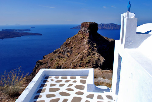
Skaros Rock
Via Flickr:
Visit Our Website! II Facebook II Twitter II Tumblr
Santorini Skaros Rock: Skaros is a rocky headland that protrudes out to the azure blue Aegean Sea. It is ideally located at the frontage of Imerovigli village. In the earlier days, a majestic castle was located here which used to be the principal place of Christian congregation in Santorini till the beginning of the 1800’s. Unfortunately, the castle was completely ruined during an earthquake in the 19th century and all that remains today are the remnants of the castle. Legend has it that the medieval castle of Skaros, was never ever conquered during its long 600 years of existence.
There is a well-defined trail that originates from the renowned Agios Georgios church that connects Skaros with the village of Imerovigli. The views are breathtaking and are literally a treat to ones eyes.
Skaros used to be the capital of Santorini till the 18th century. Later on in the 19th century, Fira became the capital due largely to its proximity and easy accessibility to the sea. Inspite of this, Skaros still retains its old world charms and has plenty to offer in terms of scenic beauty of the surrounding areas inclusive of the Caldera.
The neighborhood around Skaros is choc-a-bloc with restaurants, bars and hotels. Due to its stunning landscape and scenic beauty, many couples from the world over come here to celebrate their wedding ceremony as well as to spend their honeymoon at Skaros and the picturesque village of Imerovigli.
www.jekaworldphotography.com/
Monday, December 19, 2011
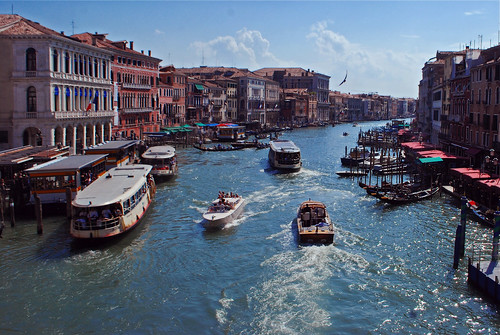
The Grand Canal
Via Flickr:
Visit Our Website! II Facebook II Twitter II Tumblr
The banks of the Grand Canal are lined with more than 170 buildings, most of which date to 13th to the 18th century and demonstrate the welfare and art created by the Republic of Venice. The noble Venetian families faced huge expenses to show off their richness in suitable palazzos: this contest reveals the citizens’ pride and the deep bond with the lagoon. Amongst the many are the Palazzi Barbaro, Ca' Rezzonico, Ca' d'Oro, Palazzo Dario, Ca' Foscari, Palazzo Barbarigo and to Palazzo Venier dei Leoni, housing the Peggy Guggenheim Collection. The churches along the canal include the basilica of Santa Maria della Salute. Centuries-old traditions such as the Historical Regatta are perpetuated every year along the Canal.
Because most of the city's traffic goes along the Canal rather than across it, only one bridge crossed the canal until the 19th century, the Rialto Bridge. There are currently two more bridges, the Ponte degli Scalzi and the Ponte dell'Accademia. A fourth, controversial bridge (Ponte della Costituzione) designed by Santiago Calatrava was recently erected, connecting the train station to the vehicle-open area of Piazzale Roma. As was usual in the past, people can still take a ferry ride across the canal at several points by standing up on the deck of a simple gondola called traghetto.
Most of the palaces emerge from water without pavement. Consequently, one can only tour past the fronts of the buildings on the grand canal by boat.
www.jekaworldphotography.com/
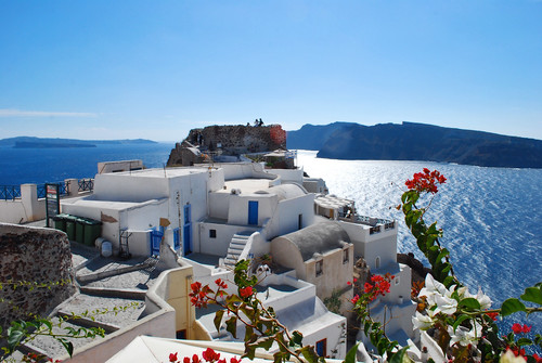
Oia Castle
Via Flickr:
Visit Our Website! II Facebook II Twitter II Tumblr
Oia (Greek: Οία, pronounced [ˈi.a]) is a former community on the islands of Thira (Santorini) and Therasia, in the Cyclades, Greece. Since the 2011 local government reform it is part of the municipality Santorini, of which it is a municipal unit. It covers the whole island Therasia and the northwesternmost part of Santorini, which it shares with the municipal unit of Santorini. The population was 1,230 inhabitants at the 2001 census, and the land area is 19.449 km2. The population and land area are distributed as follows: 962 persons on 10.150 km2 in Santorini, and 268 persons on 9.299 km2 in Therasia.
Architecture
Along the cliff of Oia, houses have been delved into the porous volcanic rock (left over from a large volcanic explosion many years ago that sunk the center of the island). Parts of these houses are visible and the scenery that results from it is generally perceived as being typically Greek. The town is noted for its picturesque architecture, unique for its blend of relatively large (for the town's space) medieval Venetian houses (dubbed "kapetanea" gr: "καπετανέα" - as they belonged to the captains) with small incave village homes, called "yposkafa" (gr: "υπόσκαφα", caved-in) which were the housing form of the rest of the town's population. This is a reminiscent of the age of Venetian rule over the island. Other attributes of this era are the large Catholic population as well as the medieval fortifications to protect from pirates. To this day laws protect the natural and architectural beauty of the town from modern manifestations, such as public electrical wires.
www.jekaworldphotography.com/