Via Flickr:
Visit Our Website! II Facebook II Twitter II Tumblr II Pinterest II Wordpress ll 500px II g+
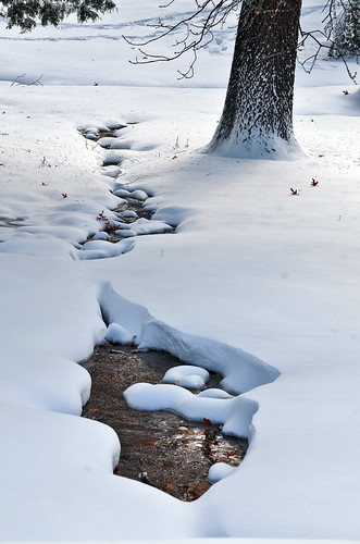
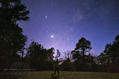
A beautiful snowy day in Arkansas
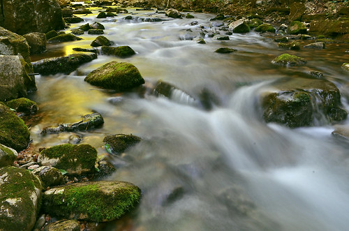
Wednesday, December 26, 2012
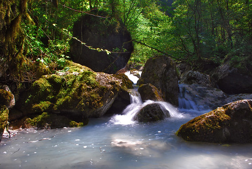
Snowy Stream
Tuesday, December 25, 2012
Monday, December 24, 2012
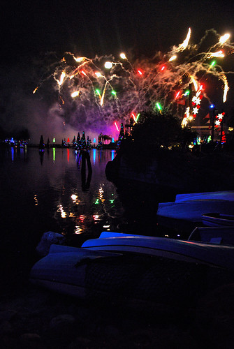
2/365 Christmas Bokeh

Saturday, December 22, 2012
Bad Moon Rising
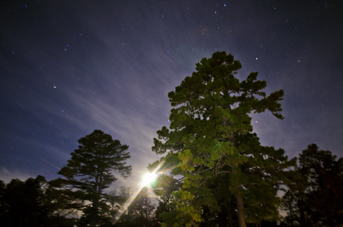
Via Flickr:
A moon rises over trees and into the beginning of the World of the Fifth Sun (According to the mayans).
Wednesday, December 19, 2012
Raindrops on Pine needles
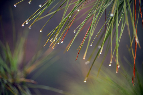
Friday, December 14, 2012
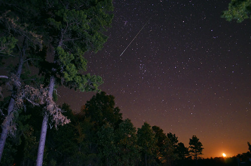
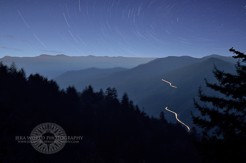
Geminid Star Trail
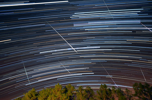
Via Flickr:
Wow the Geminid Meteor Shower sure didn't disappoint! Here is a star trail combining more than 200 30 second exposures over roughly a two hour period of time and a handful of bright meteors that fell in my frame.
Wednesday, December 5, 2012
Fall under Davies Bridge
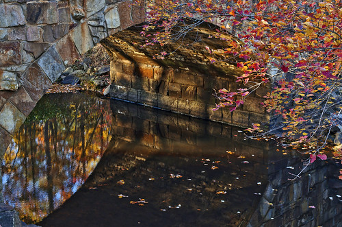
Missing the color already...here's one from a couple weeks ago of glowing evening light and autumn reflections under Davies Bridge at Petit Jean State Park.
Tuesday, December 4, 2012
Falling Water Falls
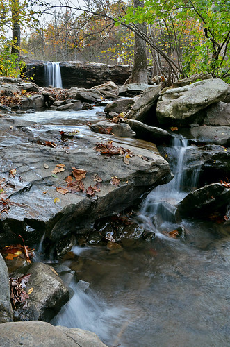
Took this shot at Falling Water Falls in the Richland Creek Wilderness Area near Ben Hur, Arkansas
Monday, December 3, 2012
City Rock Sunset
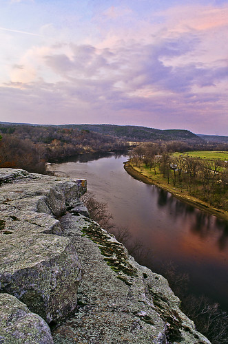
The view from City Rock Bluff overlooking the White River near Calico Rock, Arkansas was pretty amazing last with the burst of colors at sunset.
Friday, November 16, 2012
Autumn Rhythms
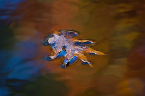
Via Flickr:
Photos of vibrant autumn leaves reflecting and abstracting off rippled water is no new concept and I have taken many of them over the years, but I've never caught one like this before. I love the way the colors interact and appear as though they were painted by some abstract expressionist.
Thursday, November 15, 2012
Pools of Autumn
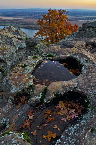
Via Flickr:
Earlier this week I was fortunate enough to witness extraordinary beauty while driving and hiking through one of the states true natural wonders...Petit Jean State Park. This shot was captured early on the cold morning where I started my journey, on the high rocky bluffs of Petit Jean Mountain's east brow, known as Stout's Point or Petit Jeans Gravesite. The rain showers on sunday had filled many of these rock cauldrons and I found them to be interesting, especially in this composition, where the textures and lines of the rock lead to this lone tree ablaze with the last of the turning fall foliage as the Arkansas River Valley seems to stretch forever in the distance.
Friday, November 9, 2012
Roark Bluff Overlook
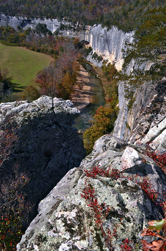
Via Flickr:
I took this shot on the edge of the 200 foot tall Roark Bluff overlooking the Buffalo River at Steel Creek Campgrounds in Northwest Arkansas.
Wednesday, October 31, 2012
Pastel Sunrise
Via Flickr:
A pastel sunrise over the Ozark Mountains in the Buffalo Wilderness of northwestern Arkansas.
Tuesday, October 30, 2012
The Annual Elk Rut
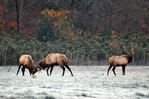
Via Flickr:
What an amazing weekend...the first cold frosty morning and peak fall color all setting the stage for many dramatic bull elk fights during the annual rut in Ponca, Arkansas.
Thursday, October 25, 2012
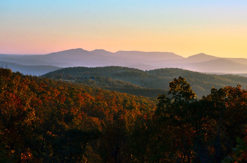
Trees are ablaze with fall color
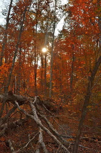
Via Flickr:
Took this photo deep in the Ozark National Forest of Northwest Arkansas where in many areas the trees are already ablaze with color.
Here is an update from Arkansas Tourism:
Northwest/North Central– In the northwest, the maples are at peak at Prairie Grove Battlefield State Park and in the downtown areas of Fayetteville, Rogers, Springdale and Bentonville. Moderate color is being reported on I-540 from Fayetteville to Mountainburg. Eureka Springs has good fall color right now and it’s getting better with each passing day. U.S. 62 from Rogers through Eureka Springs and Harrison to Mountain Home is recommended. Early-changing hardwoods are colorful now, while the oaks will require a little more time. The trees around Harrison have excellent color this week. The maples at Maplewood Cemetery and the Harrison Downtown Square are nearing peak, hickories are turning yellow and oaks are changing as well. The dogwoods and sumac along the highway are very pretty. Scenic Byway 7 has color south of Harrison to near Pelsor. The Buffalo River area is another good choice in this vicinity. In Boxley Valley, Ark. 16, 21, 43, and 74 are recommended. The Mountain View area also has color now 50%, with Scenic Highway 14 to Ark. 341 from Mountain View to Norfork recommended.
Wednesday, October 24, 2012
White-breasted Nuthatch Sitta carolensis
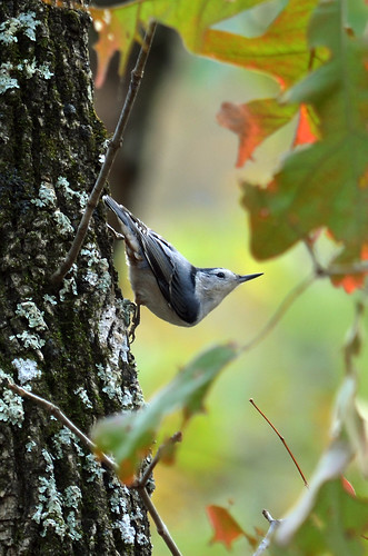
Via Flickr:
White-breasted Nuthatch (Sitta carolensis) along the Buffalo Point Overlook Trail.
Interesting Fact: Nuthatches are the only birds that can be seen climbing down tree trunks head first
Tuesday, October 23, 2012
Dillard's Ferry
Via Flickr:
Looking upriver at Dillard's Ferry Public Access during sunset. At Buffalo River National Park, Arkansas.
Thursday, September 27, 2012
The Nights a Blur
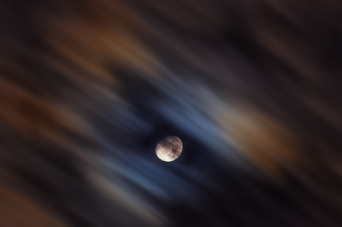
Photo of the Day: September 27th, 2012
30 sec. exposure of some fast moving clouds last night created an interesting painterly blur around the moons halo.
Wednesday, September 26, 2012
The Moon and the Monarch
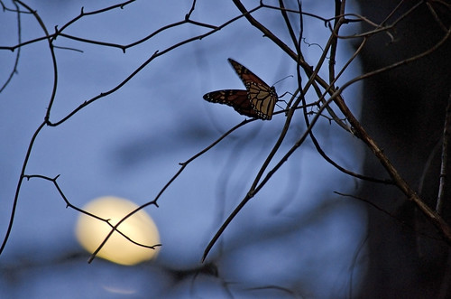
A Monarch Butterfly sits on twisted thorns as the moon rises above tree branches.
This little Monarch Butterfly really wanted its picture taken. While I photographed the Moon in its Waxing Gibbous phase the Monarch kept flying in front my lens and landing on branches and briars.
Thursday, September 20, 2012
The Great Sand Dunes National Park
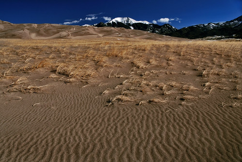
Via Flickr:
Desert ripples and grass in Great Sand Dunes National Park, Utah
Thursday, September 6, 2012
Roark Bluff Reflections
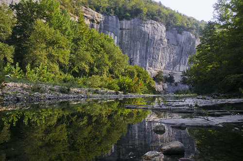
Via Flickr:
Visit Our Website! II Facebook II Twitter II Tumblr II Pinterest II Wordpress ll 500px II g+
For image licensing requests or photo related questions click here! or message me through Flickrmail.
Roark Bluff reflections near Steel Creek Buffal National River
Wednesday, August 15, 2012
Celestial Highway
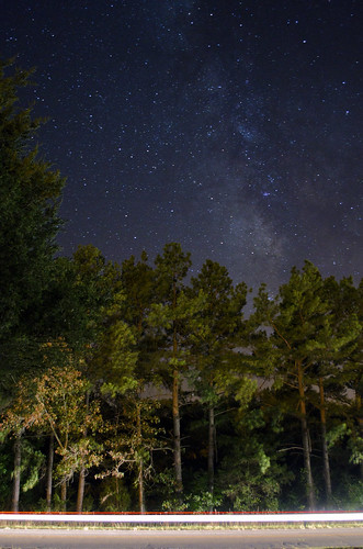
Via Flickr:
Visit Our Website! II Facebook II Twitter II Tumblr II Capture Arkansas II Wordpress ll 500px II g+
For image licensing requests or photo related questions click here! or message me through Flickrmail.
A car speeds by at 55 mph as our solar system hurdles through the galaxy at 420,000 mph
Tuesday, August 14, 2012
Little Hawksbill Crag Sunset
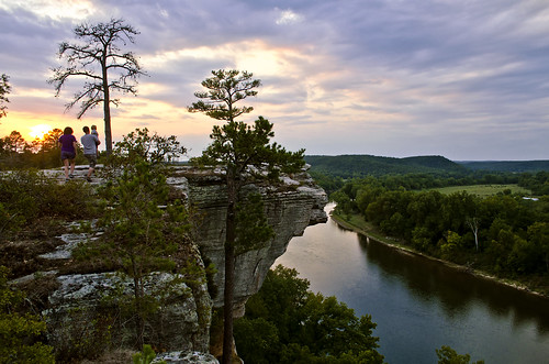
Via Flickr:
A family enjoys a scenic bluff over the White River near Calico Rock, Arkansas
Saturday, August 11, 2012
Persied Moon Rise
Via Flickr:
First night capturing one of the biggest astronomical events of the year, this weekends Persied meteor shower. After numerous shots I was lucky enough to catch one falling while the moon was rising and still bright glowing orange.
Friday, August 10, 2012
Orchard Orbweaver
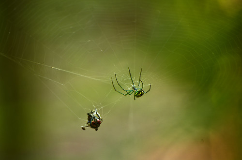
Via Flickr:
A fly is caught in an Orbweaver's web. The fly helps to show the size of the Orbweaver. The colors on the orchard are what make it so appealing and so recognizable. Its legs are a bright green and its abdomen brown on the underside has an amazing pattern of yellow, black, green and white stripes on its top, almost in a marble painted pattern. The photo gives a partial view of this pattern.
Tuesday, July 31, 2012
Friday, July 27, 2012
Zeus!
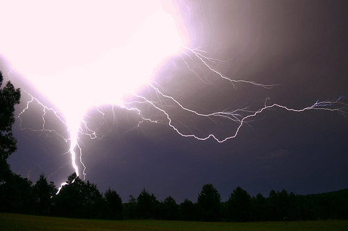
Via Flickr:
During last nights little storm I got to see and was lucky enough to capture one of the largest lightning bolts I have ever seen
Wednesday, July 11, 2012
Lake Willastein Reflections
Via Flickr:
Visit Our Website! II Facebook II Twitter II Tumblr II Capture Arkansas II Wordpress ll 500px
For image licensing requests or photo related questions click here! or message me through Flickrmail.
A calm Lake Willastein reflects its beautiful tree line
Thursday, July 5, 2012
Independence Celebration July 4th on the White River in Batesville Arkansas
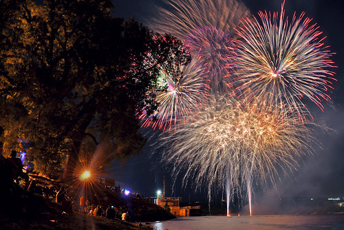
Independence Celebration July 4th on the White River in Batesville Arkansas, a photo by Jeka World Photography on Flickr.
Via Flickr:
Visit Our Website! II Facebook II Twitter II Tumblr II Capture Arkansas II Wordpress ll 500px
For image licensing requests or photo related questions click here! or message me through Flickrmail.
Independence Celebration July 4th on the White River in Batesville Arkansas
Tuesday, June 19, 2012
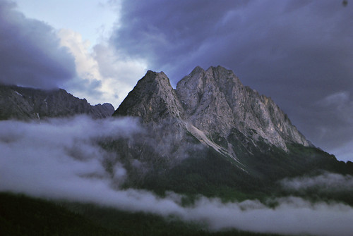
The Zugspitze Massif in the Bavarian Alps
Via Flickr:
Visit Our Website! II Facebook II Twitter II Tumblr II Capture Arkansas II Wordpress ll 500px
For image licensing requests or photo related questions click here! or message me through Flickrmail.
The highest peak in the Bavarian Alps and in Germany as a whole is the Zugspitze. It lies in the western part of the Wetterstein range and has a high Alpine character with its height of 2,962 m above NN as well as its two small glaciers.
Thursday, June 14, 2012
A Bend in the River a view from Painters Bluff in Arkansas (Press "L")
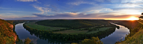
A Bend in the River a view from Painters Bluff in Arkansas (Press "L"), a photo by Jeka World Photography on Flickr.
Via Flickr:
Visit Our Website! II Facebook II Twitter II Tumblr II Capture Arkansas II Wordpress ll 500px
For image licensing requests or photo related questions click here! or message me through Flickrmail.
Painters Bluff is a cliff located in Izard County, Arkansas near Batesville and Cushman. The location can be a little difficult to find...especially for those who have never been to the spot.
GPS information:
Center: 35.8801°N 91.8526°W
Elevation at center: 758 feet (231 meters)
Quad: Batesville
Drg Name: f35091e1
Drg Source Scale: 1:100,000
Projection: NAD83/WGS84
Thursday, June 7, 2012
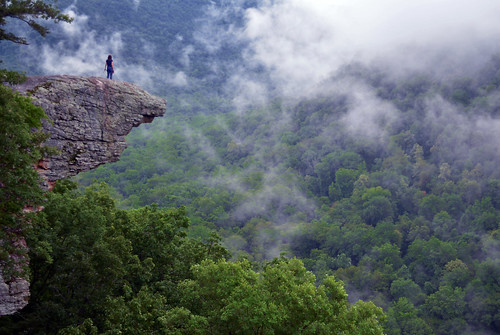
Up In The Clouds on Hawksbill Crag
Via Flickr:
Visit Our Website! II Facebook II Twitter II Tumblr II Capture Arkansas II Wordpress ll 500px
For image licensing requests or photo related questions click here! or message me through Flickrmail.
Wispy, smoke-like fog hangs around Hawksbill Crag after a cool rain shower.
Hawksbill Crag is one of the most recognized spots in Arkansas because photos of it have been used in many publications about the state and the Ozark Mountains. It is an amazing rock outcrop that sticks out from a tall bluff located in the Upper Buffalo Wilderness Area.
Wednesday, June 6, 2012
Great Falls National Park
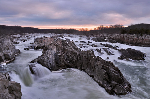
Via Flickr:
Visit Our Website! II Facebook II Twitter II Tumblr II Capture Arkansas II Wordpress ll 500px
For image licensing requests or photo related questions click here! or message me through Flickrmail.
Check out Jeka World Photography's new Wordpress blog for photo tour of
Great Falls National Park!!!
At Great Falls, the Potomac River builds up speed and force as it falls over a series of steep, jagged rocks and flows through the narrow Mather Gorge. The Patowmack Canal offers a glimpse into the early history of this country. Great Falls Park has many opportunities to explore history and nature, all in a beautiful 800-acre park only 15 miles from the Nation's Capital.
Tuesday, June 5, 2012

Saturday, May 12, 2012
A Painted Stream
Via Flickr:
Visit Our Website! II Facebook II Twitter II Tumblr II Capture Arkansas
For image licensing requests or photo related questions click here! or message me through Flickrmail!
___________________________________________
Sunlight shining through the bright green canopies high above paint parts of the stream with a beautiful greenish/yellow glow.
About Blanchard Springs:
Rainwater falling on the Ozarks has soaked into the ground for millions of years. As it moved through cracks in the limestone bedrock, it dissolved the stone and slowly widened the cracks to form Blanchard Springs Caverns.The water remained in the caverns until surface erosion carved valleys and allowed the water to escape. You are in such a valley now. As this valley cut deeper and deeper, lower sections of the cave were drained. New springs then developed below older dried-up springs. Blanchard Springs probably came out of the holes high on the bluff above us many years ago, when the streambed lay 20 to 30 feet above its present level.
This stream flows through bat sanctuaries on its way through Blanchard Springs Caverns. The water is enriched because of bat wastes and the decaying remains of those that died. Although this does not affect the appearance of the water, it does make it unsafe to drink.
Wednesday, May 9, 2012
Valley Sunset
Via Flickr:
Visit Our Website! II Facebook II Twitter II Tumblr II Capture Arkansas
For image licensing requests or photo related questions click here! or message me through Flickrmail!
___________________________________________
About Great Smoky Mountains National Park:
---------------------------------------------------------------------------
Great Smoky Mountains National Park is a United States National Park and UNESCO World Heritage Site that straddles the ridgeline of the Great Smoky Mountains, part of the Blue Ridge Mountains, which are a division of the larger Appalachian Mountain chain. The border between Tennessee and North Carolina runs northeast to southwest through the centerline of the park. It is the most visited national park in the United States. On its route from Maine to Georgia, the Appalachian Trail also passes through the center of the park. The park was chartered by the United States Congress in 1934 and officially dedicated by President Franklin Delano Roosevelt in 1940. It encompasses 814 square miles (2,110 km2), making it one of the largest protected areas in the eastern United States. The main park entrances are located along U.S. Highway 441 (Newfound Gap Road) at the towns of Gatlinburg, Tennessee, and Cherokee, North Carolina. It was the first national park whose land and other costs were paid for in part with federal funds; previous parks were funded wholly with state money or private funds.
Thursday, April 19, 2012
MARVEL (The stark realization that we are just a speck on this earth and time)
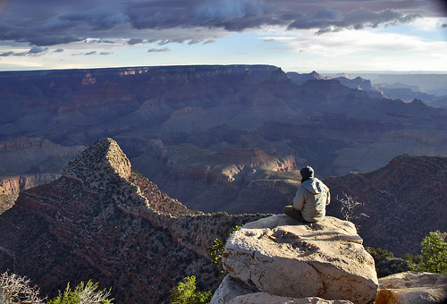
MARVEL (The stark realization that we are just a speck on this earth and time), a photo by Jeka World Photography on Flickr.
Via Flickr:
Visit Our Website! II Facebook II Twitter II Tumblr II Capture Arkansas
For image licensing requests or photo related questions click here! or message me through Flickrmail!
___________________________________________
The Story:
---------------------------------------------------------------------------
Some travel sights in this world evoke so much emotion, and truly inspire awe. The Grand Canyon is probably the world’s most impressive natural wonder, and one can never seem to adequately express the grandeur of this sight. Setting up the tripod and sitting out on this rock outcrop I hoped to actually convey a little of this feeling to the viewer.
___________________________________________
About The Grand Canyon:
---------------------------------------------------------------------------
The Grand Canyon is a steep-sided canyon carved by the Colorado River in the United States in the state of Arizona. It is largely contained within the Grand Canyon National Park, one of the first national parks in the United States. President Theodore Roosevelt was a major proponent of preservation of the Grand Canyon area, and visited it on numerous occasions to hunt and enjoy the scenery.
The Grand Canyon is 277 miles (446 km) long, up to 18 miles (29 km) wide and attains a depth of over a mile (6,000 feet / 1,800 metres) Nearly two billion years of the Earth's geological history have been exposed as the Colorado River and its tributaries cut their channels through layer after layer of rock while the Colorado Plateau was uplifted. While the specific geologic processes and timing that formed the Grand Canyon are the subject of debate by geologists, recent evidence suggests the Colorado River established its course through the canyon at least 17 million years ago. Since that time, the Colorado River continued to erode and form the canyon to its present-day configuration.
Before European immigration, the area was inhabited by Native Americans who built settlements within the canyon and its many caves. The Pueblo people considered the Grand Canyon ("Ongtupqa" in Hopi language) a holy site and made pilgrimages to it. The first European known to have viewed the Grand Canyon was García López de Cárdenas from Spain, who arrived in 1540.
Saturday, April 14, 2012
EDEN
Via Flickr:
Visit Our Website! II Facebook II Twitter II Tumblr ll 500px II Capture Arkansas
For image licensing requests or photo related questions click here! or message me through Flickrmail!
This is part of the white river formed by glacier melt that runs through the Partnachklamm.
About PARTNACHKLAMM:
One of Germany’s natural wonders lies just around the corner from the twin towns of Garmisch-Partenkirchen in the Bavarian Alps.
The Partnachklamm is a spectacular 700m gorge that frames a surging white-water river.
You can walk the length of the gorge along a pathway cut into the limestone rock just a few metres above the river.
Tuesday, April 10, 2012
Summer Nights on Lake Garda
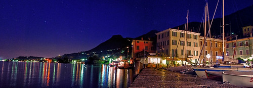
Via Flickr:
Visit Our Website! II Facebook II Twitter II Tumblr II Capture Arkansas
For image licensing requests or photo related questions click here! or message me through Flickrmail!
About Gargnano:
This small port town was an important Franciscan center in the 13th century, and now comes alive in the summer months when German tourists, many of whom have villas here, crowd the small pebble beaches. An Austrian flotilla bombarded the town in 1866, and some of the houses still bear marks of cannon fire. Mussolini owned two houses in Gargnano: one is now a language school and the other, Villa Feltrinelli, has been restored and reopened as a luxury hotel.
About Lake Garda:
Lake Garda (Italian: Lago di Garda or Benaco) is the largest lake in Italy. It is located in Northern Italy, about half-way between Brescia and Verona, and between Venice and Milan. Glaciers formed this alpine region at the end of the last ice age. The lake and its shoreline are divided between the provinces of Verona (to the southeast), Brescia (southwest), and Trentino (north). Being easily accessible from the north via the Brenner Pass, the lake is a major tourist destination, including a number of exclusive hotels and resorts along its shore.
The northern part of the lake is narrower, surrounded by mountains, the majority of which belong to the Gruppo del Baldo. The shape is typical of a moraine valley, probably having been formed under the action of a Paleolithic glacier. Although traces of the glacier's actions are evident today, in more recent years it has been hypothesized that the glacier occupied a previously existing depression, created by stream erosion 5 to 6 million years ago.
The lake has numerous small islands and five main ones, the largest being Isola del Garda. Nearby to the south is Isola San Biagio, also known as the Isola dei Conigli ("Island of the Rabbits"). Both are offshore of San Felice del Benaco, on the west side. The three other main islands are Isola dell'Olivo, Isola di Sogno, and Isola di Trimelone, all further north near the east side. The main tributary is the Sarca River, while the only emissary is the Mincio River.
[edit]Localities and sights
The ancient fortified town of Sirmione, located on the south of the lake, is one particularly popular destination, home to the Virgilio & Catullo Spa Complexes, as well as numerous restaurants, bars, hotels, fashion stores and a market. The picturesque Scaliger castle dates from the 13th century. The Roman poet Catullus had a villa here, and visitors can see a ruined Roman spa named the Grotte di Catullo (Grotto of Catullus) although there is no evidence linking him to this particular building. The sulfur springs at the tip of the peninsula have a reputation for the healing of catarrhal conditions, particularly those involving the ear. Nearby, there is Gardaland, one of the most famous theme parks in Italy.
Friday, April 6, 2012
The Magic of Bruges

Via Flickr:
Visit Our Website! II Facebook II Twitter II Tumblr II Capture Arkansas
For image licensing requests or photo related questions click here! or message me through Flickrmail!
One evening while wondering the cobblestone alleys of Bruges the soaring 119m (396-ft.) spire of the Church of Our Lady (Onze-Lieve-Vrouwekerk) standing high above the streets and canals, seemed to almost glow red as the last rays of the days sunlight clung to it. Bruges is truly a magical place despite how colin farrells character on in Bruges felt about it. “If I'd grown up on a farm and was retarded, Bruges might impress me. But I didn't, so it doesn't.” A medieval city that makes you go back centuries the first second you enter it, through its old houses, canals with beautiful swans and warm, picturesque market squares. The bourgeois feeling is mesmerizing you wherever you go, on the cobbled streets with charming historical houses or along the canals that you can find almost anywhere. The historic city centre was added to the Unesco’s World Heritage List and the current city boundaries still coincide exactly with those of the medieval city centre.
About The Church of Our Lady:
(Dutch: Onze-Lieve-Vrouwekerk) in Bruges, Belgium, dates mainly from the 13th, 14th and 15th centuries.
Its tower, at 119 meters in height, remains the tallest structure in the city and the second tallest brickwork tower in the world (the tallest being the St. Martin's Church in Landshut, Germany).
In the choir space behind the high altar are the tombs of Charles the Bold, last Valois Duke of Burgundy, and his daughter, the duchess Mary. The gilded bronze effigies of both father and daughter repose at full length on polished slabs of black stone. Both are crowned, and Charles is represented in full armor and wearing the decoration of the Order of the Golden Fleece.
The altarpiece of the large chapel in the southern aisle enshrines the most celebrated art treasure of the church—a white marble sculpture of the Madonna and Child created by Michelangelo around 1504. Probably meant originally for Siena Cathedral, it was purchased in Italy by two Brugean merchants, the brothers Jan and Alexander Mouscron, and in 1514 donated to its present home. The sculpture was twice recovered after being looted by foreign occupiers—French revolutionaries circa 1794 and Nazi Germans in 1944.
About Bruges:
/ˈbruːʒ/ in English; Dutch: Brugge, [ˈbrʏʝə], French: Bruges, [ˈbʁyːʒ], German: Brügge, [ˈbrʏɡə]) is the capital and largest city of the province of West Flanders in the Flemish Region of Belgium. It is located in the northwest of the country.
The historic city centre is a prominent World Heritage Site of UNESCO. It is oval-shaped and about 430 hectares in size. The area of the whole city amounts to more than 13,840 hectares, including 1,075 hectares off the coast, at Zeebrugge (meaning "Brugge aan Zee" or "Bruges on Sea"). The city's total population is 117,073 (1 January 2008), of which around 20,000 live in the historic centre. The metropolitan area, including the outer commuter zone, covers an area of 616 km² and has a total of 255,844 inhabitants as of 1 January 2008.
Along with a few other canal-based northern cities, such as Amsterdam, it is sometimes referred to as "The Venice of the North".
Bruges has a significant economic importance thanks to its port. At one time, it was the "chief commercial city" of the world.
Thursday, April 5, 2012
The Magic of Bruges
Via Flickr:
Visit Our Website! II Facebook II Twitter II Tumblr II Capture Arkansas
For image licensing requests or photo related questions click here! or message me through Flickrmail!
One evening while wondering the cobblestone alleys of Bruges the soaring 119m (396-ft.) spire of the Church of Our Lady (Onze-Lieve-Vrouwekerk) standing high above the streets and canals, seemed to almost glow red as the last rays of the days sunlight clung to it. Bruges is truly a magical place despite how colin farrells character on in Bruges felt about it. “If I'd grown up on a farm and was retarded, Bruges might impress me. But I didn't, so it doesn't.” A medieval city that makes you go back centuries the first second you enter it, through its old houses, canals with beautiful swans and warm, picturesque market squares. The bourgeois feeling is mesmerizing you wherever you go, on the cobbled streets with charming historical houses or along the canals that you can find almost anywhere. The historic city centre was added to the Unesco’s World Heritage List and the current city boundaries still coincide exactly with those of the medieval city centre.
About The Church of Our Lady:
(Dutch: Onze-Lieve-Vrouwekerk) in Bruges, Belgium, dates mainly from the 13th, 14th and 15th centuries.
Its tower, at 119 meters in height, remains the tallest structure in the city and the second tallest brickwork tower in the world (the tallest being the St. Martin's Church in Landshut, Germany).
In the choir space behind the high altar are the tombs of Charles the Bold, last Valois Duke of Burgundy, and his daughter, the duchess Mary. The gilded bronze effigies of both father and daughter repose at full length on polished slabs of black stone. Both are crowned, and Charles is represented in full armor and wearing the decoration of the Order of the Golden Fleece.
The altarpiece of the large chapel in the southern aisle enshrines the most celebrated art treasure of the church—a white marble sculpture of the Madonna and Child created by Michelangelo around 1504. Probably meant originally for Siena Cathedral, it was purchased in Italy by two Brugean merchants, the brothers Jan and Alexander Mouscron, and in 1514 donated to its present home. The sculpture was twice recovered after being looted by foreign occupiers—French revolutionaries circa 1794 and Nazi Germans in 1944.
About Bruges:
/ˈbruːʒ/ in English; Dutch: Brugge, [ˈbrʏʝə], French: Bruges, [ˈbʁyːʒ], German: Brügge, [ˈbrʏɡə]) is the capital and largest city of the province of West Flanders in the Flemish Region of Belgium. It is located in the northwest of the country.
The historic city centre is a prominent World Heritage Site of UNESCO. It is oval-shaped and about 430 hectares in size. The area of the whole city amounts to more than 13,840 hectares, including 1,075 hectares off the coast, at Zeebrugge (meaning "Brugge aan Zee" or "Bruges on Sea"). The city's total population is 117,073 (1 January 2008), of which around 20,000 live in the historic centre. The metropolitan area, including the outer commuter zone, covers an area of 616 km² and has a total of 255,844 inhabitants as of 1 January 2008.
Along with a few other canal-based northern cities, such as Amsterdam, it is sometimes referred to as "The Venice of the North".
Bruges has a significant economic importance thanks to its port. At one time, it was the "chief commercial city" of the world.
Wednesday, April 4, 2012
Rocky Sunset
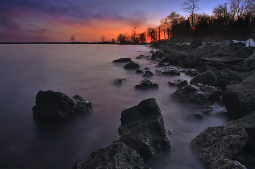
Via Flickr:
Visit Our Website! II Facebook II Twitter II Tumblr II Capture Arkansas
For image licensing requests or photo related questions click here! or message me through Flickrmail!
North Point State Park is a Chesapeake Bay waterfront park located in Edgemere, MD. The park is situated on the grounds that once were the home of Bay Shore Amusement Park, which was one of the premiere amusement parks in Maryland from 1906 - 1947. Current visitors to the park can enjoy hiking, wading, birdwatching, bicycling, fishing, picnicking, group events, and remnants of Bay Shore Park, such as the restored Trolley Station and fountain.
Saturday, March 10, 2012
Staccato Spiral
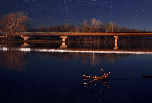
Via Flickr:
Visit Our Website! II Facebook II Twitter II Tumblr II Capture Arkansas
For image licensing requests or photo related questions click here! or message me through Flickrmail!
The waters of the White River stilled by Lock and Dam #1 in Batesville, Arkansas reflect in stark contrast a busy city bridge and staccato star trails as the world spins madly on.
- Jeka World Photography
Thursday, March 1, 2012
Under Venus and Jupiter
Via Flickr:
Visit Our Website! II Facebook II Twitter II Tumblr II Capture Arkansas
For image licensing requests or photo related questions click here! or message me through Flickrmail!
The most casual viewer of the night sky this winter cannot help to notice the dominance of planets Venus and Jupiter in the west. Following evening twilight and even before the sky is fully dark, these two brilliant planets stand out, piercing the deepening blue. Venus is the brighter of the two. As the planets continue their procession - that includes our Earth in its travels - Jupiter and Venus are appearing closer and closer together. They will be closest - in conjunction - on March 15, only 3 degrees apart (six widths of the moon).
30 Second Exposure
Wednesday, February 29, 2012
Endless Horizon
Via Flickr:
Visit Our Website! II Facebook II Twitter II Tumblr II Capture Arkansas
For image licensing requests or photo related questions click here! or message me through Flickrmail!
North Point State Park is a Chesapeake Bay waterfront park located in Edgemere, MD. The park is situated on the grounds that once were the home of Bay Shore Amusement Park, which was one of the premiere amusement parks in Maryland from 1906 - 1947. Current visitors to the park can enjoy hiking, wading, birdwatching, bicycling, fishing, picnicking, group events, and remnants of Bay Shore Park, such as the restored Trolley Station and fountain.
Saturday, February 25, 2012
Mossy cascade in mountain stream. Great Smoky Mountains National Park, Tennessee, Appalachian, USA
Mossy cascade in mountain stream. Great Smoky Mountains National Park, Tennessee, Appalachian, USA, a photo by Jeka World Photography (Catching up!!) on Flickr.
Via Flickr:
Visit Our Website! II Facebook II Twitter II Tumblr II Capture Arkansas
For image licensing requests or photo related questions click here! or message me through Flickrmail!
Great Smoky Mountains National Park is a United States National Park and UNESCO World Heritage Site that straddles the ridgeline of the Great Smoky Mountains, part of the Blue Ridge Mountains, which are a division of the larger Appalachian Mountain chain. The border between Tennessee and North Carolina runs northeast to southwest through the centerline of the park. It is the most visited national park in the United States. On its route from Maine to Georgia, the Appalachian Trail also passes through the center of the park. The park was chartered by the United States Congress in 1934 and officially dedicated by President Franklin Delano Roosevelt in 1940. It encompasses 814 square miles (2,110 km2), making it one of the largest protected areas in the eastern United States. The main park entrances are located along U.S. Highway 441 (Newfound Gap Road) at the towns of Gatlinburg, Tennessee, and Cherokee, North Carolina. It was the first national park whose land and other costs were paid for in part with federal funds; previous parks were funded wholly with state money or private funds.
Elevations in the park range from 876 feet (267 m) at the mouth of Abrams Creek to 6,643 feet (2,025 m) at the summit of Clingmans Dome. Within the park a total of sixteen mountains reach higher than 6,000 feet (1829 m).
The wide range of elevations mimics the latitudinal changes found throughout the entire eastern United States. Indeed, ascending the mountains is comparable to a trip from Tennessee to Canada. Plants and animals common in the country's Northeast have found suitable ecological niches in the park's higher elevations, while southern species find homes in the balmier lower reaches.
The observation tower at Clingmans Dome, the highest point in the national park.
During the most recent ice age, the northeast-to-southwest orientation of the Appalachian mountains allowed species to migrate southward along the slopes rather than finding the mountains to be a barrier. As climate warms, many northern species are now retreating upward along the slopes and withdrawing northward,[8] while southern species are expanding.[9]
The park normally has very high humidity and precipitation, averaging from 55 inches (1,400 mm) per year in the valleys to 85 inches (2,200 mm) per year on the peaks. This is more annual rainfall than anywhere in the United States outside the Pacific Northwest and parts of Alaska. It is also generally cooler than the lower elevations below, and most of the park has a humid continental climate more comparable to locations much farther north, as opposed to the humid subtropical climate in the lowlands. The park is almost 95 percent forested, and almost 36 percent of it, 187,000 acres (760 km2), is estimated by the Park Service to be old growth forest with many trees that predate European settlement of the area. It is one of the largest blocks of deciduous, temperate, old growth forest in North America.
The variety of elevations, the abundant rainfall, and the presence of old growth forests give the park an unusual richness of biota. About 10,000 species of plants and animals are known to live in the park, and estimates as high as an additional 90,000 undocumented species may also be present.
Park officials count more than 200 species of birds, 66 species of mammals, 50 species of fish, 39 species of reptiles, and 43 species of amphibians, including many lungless salamanders. The park has a noteworthy black bear population, numbering at least 1,800. An experimental re-introduction of elk (wapiti) into the park began in 2001.
Over 100 species of trees grow in the park. The lower region forests are dominated by deciduous leafy trees. At higher altitudes, deciduous forests give way to coniferous trees like Fraser Fir. In addition, the park has over 1,400 flowering plant species and over 4,000 species of non-flowering plants.
Friday, February 24, 2012
The Beacon
Via Flickr:
Visit Our Website! II Facebook II Twitter II Tumblr II Capture Arkansas
For image licensing requests or photo related questions click here! or message me through Flickrmail!
Sandy Point State Park is a Maryland state park located at Sandy Point, at the western end of the Chesapeake Bay Bridge in Anne Arundel County, Maryland.[1] The park is at the site of a former ferry landing that served the Chesapeake Bay Ferry System. Located at the park is the historic home Sandy Point Farmhouse, listed on the National Register of Historic Places in 1972.
Thursday, February 23, 2012
Smoky Mountain Trails
Via Flickr:
Visit Our Website! II Facebook II Twitter II Tumblr II Capture Arkansas
For image licensing requests or photo related questions click here! or message me through Flickrmail!
We had to brave a cold morning on top of the smokies for quite a while for this image. Taking numerous long shutter captures throughout the morning and layering them later. In the end I believe that it was all definitely worth it!
Great Smoky Mountains National Park is a United States National Park and UNESCO World Heritage Site that straddles the ridgeline of the Great Smoky Mountains, part of the Blue Ridge Mountains, which are a division of the larger Appalachian Mountain chain. The border between Tennessee and North Carolina runs northeast to southwest through the centerline of the park. It is the most visited national park in the United States. On its route from Maine to Georgia, the Appalachian Trail also passes through the center of the park. The park was chartered by the United States Congress in 1934 and officially dedicated by President Franklin Delano Roosevelt in 1940. It encompasses 814 square miles (2,110 km2), making it one of the largest protected areas in the eastern United States. The main park entrances are located along U.S. Highway 441 (Newfound Gap Road) at the towns of Gatlinburg, Tennessee, and Cherokee, North Carolina. It was the first national park whose land and other costs were paid for in part with federal funds; previous parks were funded wholly with state money or private funds.
Wednesday, February 22, 2012
All That Remains

Via Flickr:
Visit Our Website! II Facebook II Twitter II Tumblr II Capture Arkansas
For image licensing requests or photo related questions click here! or message me through Flickrmail!
About North Point Park:
North Point State Park is located in Baltimore County on the shores of the Chesapeake Bay and is surrounded by beautiful and fascinating natural and historical resources. It consists of 1,310 acres off Old North Point Road in Edgemere.
About The Chesapeake Bay:
The Chesapeake Bay is the largest estuary in the United States. It lies off the Atlantic Ocean, surrounded by Maryland and Virginia. The Chesapeake Bay's drainage basin covers 64,299 square miles (166,534 km2) in the District of Columbia and parts of six states: New York, Pennsylvania, Delaware, Maryland, Virginia, and West Virginia. More than 150 rivers and streams drain into the bay.
The Chesapeake Bay is approximately 200 miles (300 km) long, from the Susquehanna River in the north to the Atlantic Ocean in the south. At its narrowest point between Kent County's Plum Point (near Newtown) and the Harford County shore near Romney Creek, the bay is 2.8 miles (4.5 km) wide; at its widest point, just south of the mouth of the Potomac River, it is 30 miles (50 km) wide. Total shoreline for the bay and its tributaries is 11,684 miles (18,804 km), and the surface area of the bay and its major tributaries is 4,479 square miles (11,601 km2). Average depth of the bay is 46 feet (14 m) and the maximum depth is 208 feet (63 m).
The bay is spanned in two places. The Chesapeake Bay Bridge crosses the bay in Maryland from Sandy Point (near Annapolis) to Kent Island; and the Chesapeake Bay Bridge-Tunnel in Virginia connects Virginia Beach to Cape Charles. The bay has environmental issues but is noted for its beauty; in recent years, a pattern has been that it is becoming "emptier", with fewer crabs, oysters, and watermen.
Subscribe to:
Posts (Atom)